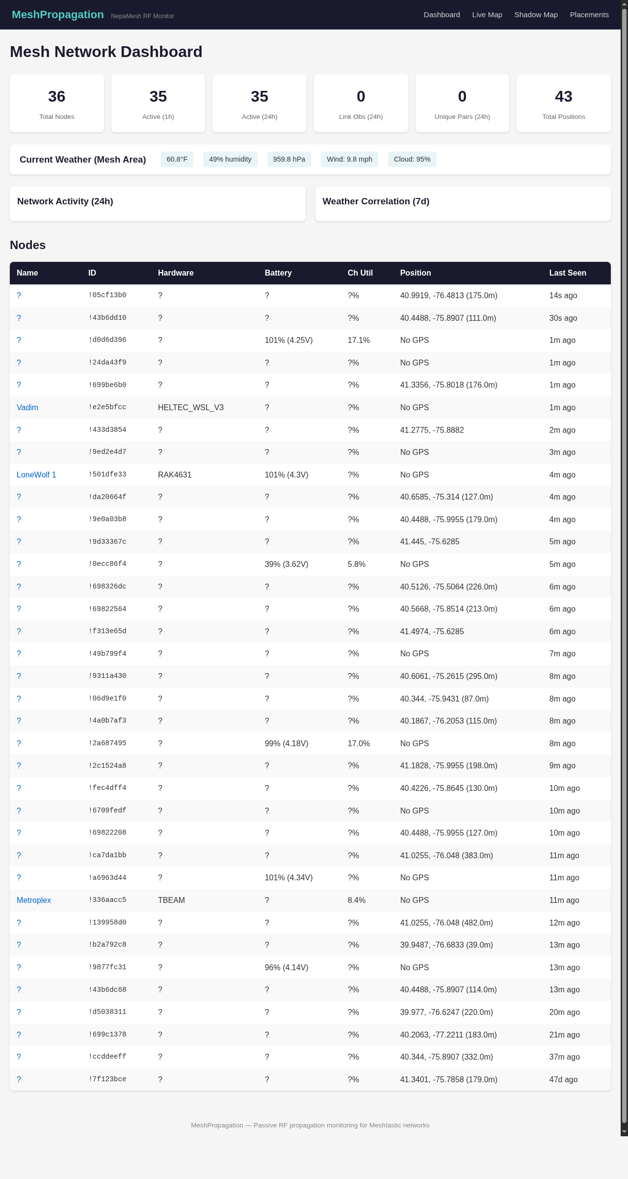
May on the Mesh: 321 Active Nodes, Two Airplanes, and LoRa at 20,000 Feet
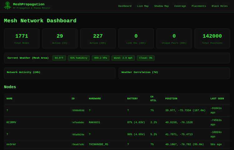
The number that matters for May: 321 nodes active in the last 24 hours. That’s up from 246 in April — a real 30% increase in daily-active nodes contributing to the mesh.
The total node count ballooned to 1,228, but that number deserves a footnote. Meshtastic nodes that pass through the area — including, as we’ll get to, nodes on commercial flights — leave records in the database. Stale hardware, weekend deployments, nodes that came online once and went silent: they all accumulate. The total is a historical artifact. The active count is the actual network.
By the Numbers
All data pulled May 31, 2026.
321 nodes active in the last 24 hours. Average RSSI: -97.4 dBm. Average SNR: -6.70 dB. Both are slight improvements over April’s -98.9 dBm and -8.3 dB — more nodes relaying means better path diversity and cleaner average signal. That’s how mesh is supposed to work.
Of the nodes, 758 have GPS positions in the dataset. If you’re running without MQTT uplink, the setup takes five minutes and gets you on the map.
Hardware breakdown, named devices only — the 637 nodes showing no hardware type are probably running older firmware or have telemetry disabled:
| Hardware | Count | Notes |
|---|---|---|
| RAK4631 | 163 | Still the outdoor workhorse |
| Heltec V3 | 120 | Budget staple |
| Heltec V4 | 65 | Gaining ground on the V3 |
| Seeed Wio Tracker | 28 | GPS tracker crowd |
| Tracker T1000-E | 28 | Credit-card sized |
| PORTDUINO (Linux) | 25 | Infrastructure backbone |
| T-Beam | 24 | OG hardware, still running |
| Heltec Mesh Node T114 | 22 | Ultra-low power nRF52 |
| Seeed Solar Node | 20 | Permanent outdoor deployments |
| T-Deck | 15 | The keyboard nodes |
The solar node count going from six to twenty is the one worth noting. Permanent outdoor solar deployments aren't weekend projects — they're people committing real time and money to the infrastructure. That's a meaningful shift.
Two Flights Joined the Mesh
This is the part worth talking about.
On April 28 at approximately 16:00, a node called "corruptedstack MeshPocket | nyme.sh" appeared in the propagation data.
Altitude: 18,708 feet.
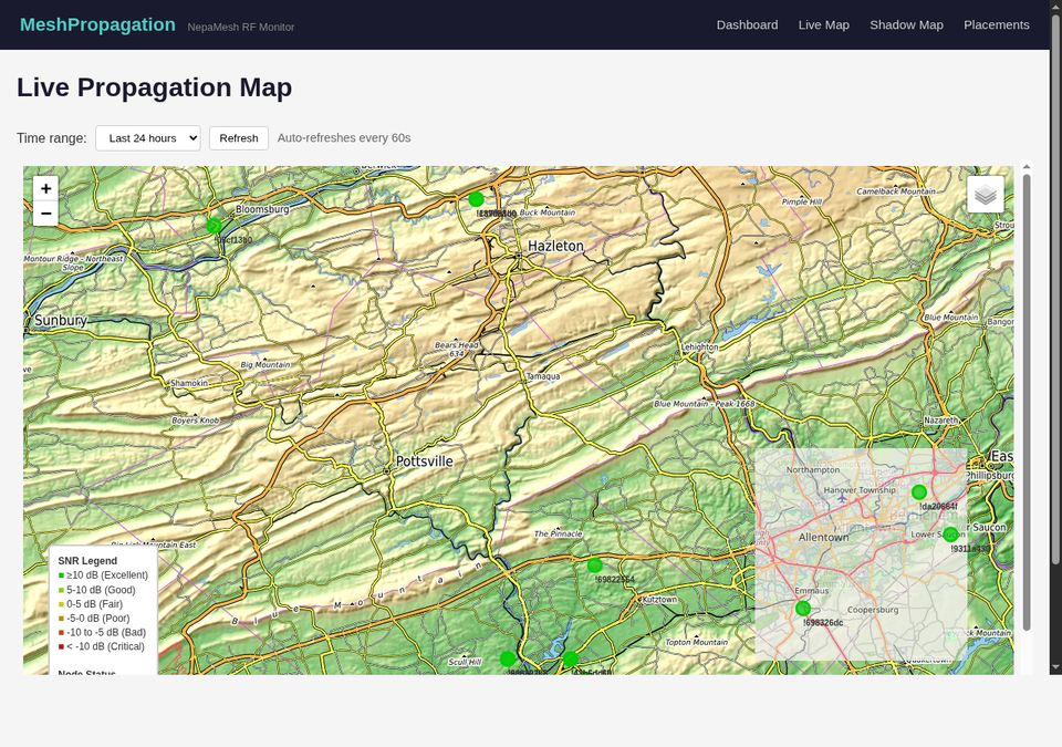
It was over lat 41.13, lon -76.10 — directly above the Susquehanna River corridor in the Wyoming Valley, a few miles north of Wilkes-Barre. Hardware: Heltec Mesh Pocket, one of those credit-card-sized LoRa devices that fits in a shirt pocket. Role: CLIENT_MUTE. Someone had it in their bag on a flight, it woke up at altitude, and it spent however long it was over NEPAMesh territory listening to the network below.
The geometry of what happened next is the interesting part.
At 18,708 feet, the radio horizon extends roughly 270 km (167 miles) to sea level. When that node was over the Wyoming Valley, 734 NEPAMesh ground nodes were within geometric line of sight. Every node within that circle with a clear sky overhead was a potential link partner. Bears Head — the network's highest and most-connected node at 2,146 feet — was 19.5 miles away. The corruptedstack node was practically overhead.
Then, on May 15 at 09:47, a second airplane node appeared: !994e19a8, at 20,031 feet over Wayne County — just northeast of the Wyoming Valley. No name, no hardware identifier, just a node at altitude over northeastern Pennsylvania. Horizon from that altitude: 279 km (173 miles). Ground nodes within line of sight: 711.
The longest potential link from that event — from !994e19a8 to a ground node at 1,683 feet elevation within its line of sight — works out to 331 km (205.9 miles).
Distance Records: Ground vs. Air
These are two different leaderboards and it's worth keeping them separate.
Ground-based record (verified RF link, no altitude assist):
| Distance | From | To | SNR | Miles |
|---|---|---|---|---|
| 127.5 km | Bears Head (W3TWA, 2,146 ft) | MountHollyRptr | -13.8 dB | 79.2 mi |
| 104.1 km | Bears Head (W3TWA) | York (W3HZU) | -9.1 dB | 64.7 mi |
| 79.2 km | !22b35655 | Vinemont1100 | -16.9 dB | 49.2 mi |
These links required ridge-top antenna placement, good hardware, and favorable propagation. Bears Head at 2,146 feet is doing a lot of work. The 79.2-mile link is a genuine ground-level achievement.
Airplane-assisted record (altitude-aided, line-of-sight to horizon):
| Node | Altitude | Date | Ground Nodes in LoS | Max Possible Link |
|---|---|---|---|---|
| !994e19a8 | 20,031 ft | May 15 | 711 | 331 km (205.9 mi) |
| corruptedstack MeshPocket | 18,708 ft | Apr 28 | 734 | 319 km (198.1 mi) |
These are theoretical maximums based on geometric line-of-sight calculation — the ground nodes were reachable from those altitudes, but confirmed individual link records require neighbor data that the firmware didn't relay. What is confirmed: both nodes appeared in the NEPAMesh MQTT data, which means at least one ground gateway heard them. The range from there is a geometry problem, not speculation.
The Meshtastic world record is 206 miles. The airplane record, if confirmed (which it isn't), would tie it.
Why This Works (And Why It's Not Cheating)
LoRa at 915 MHz doesn't have opinions about your transportation mode. It has path loss math and a noise floor, and it works when the signal arrives above that floor.
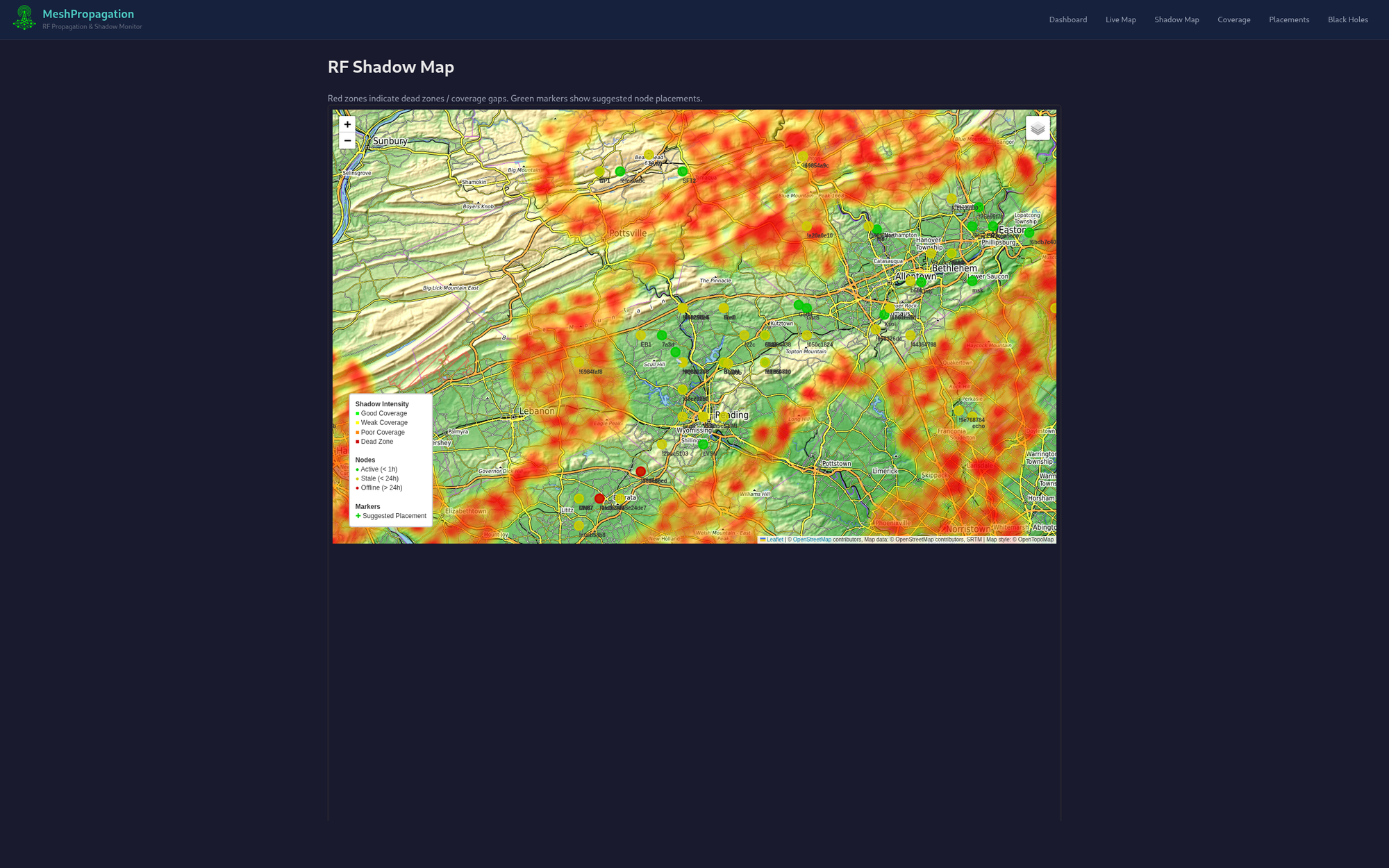
The terrain problem that governs almost everything about ground-level mesh performance — ridge blocking, valley shadows, Fresnel zone violations — disappears at altitude. From 20,000 feet, Moosic Mountain doesn't exist as an obstacle. The entire Wyoming Valley topography that the shadow map spends all its time describing becomes irrelevant. The path is air.
The path loss over 200 miles is severe. Free-space loss at 915 MHz over 330 km is around 138 dB. A typical LoRa link budget at Spreading Factor 12 is about 157 dB. That's 19 dB of margin — thin, but real. The radio can decode signals that arrive well below the noise floor. That's what the spreading factor system exists for. Short-range WiFi can't do this. LoRa can.
So: not cheating. Physics. Unusual physics, but physics.
What an Airplane Node Looks Like
If you're watching map.nepamesh.com and something unusual appears, here's how to identify it:
- Altitude reported in thousands of feet — the two events this month were at 18,708 and 20,031 feet. Nothing on the ground gets close to that.
- No speed or heading data — airplane nodes typically report position via GPS but don't always push speed/heading, depending on firmware settings and motion thresholds.
- Short duration — a commercial flight crosses the Wyoming Valley in under fifteen minutes. The node appears, the data gets captured, it's gone.
- MQTT gateway capture — we see these nodes because one of our MQTT-connected ground nodes heard them and uploaded the position. If you're running a gateway and you hear a node at 20,000 feet, you're part of why we know about it.
The corruptedstack node is the more compelling of the two. It's a named, identifiable device. The owner has a website (nyme.sh). It was on a Heltec Mesh Pocket. And it was directly over our network — 19.5 miles from Bears Head — when it checked in. It was doing what CLIENT_MUTE is supposed to do: listening, not transmitting. It caught the mesh at altitude and left a position record in our database.
The Rest of May
propagation.nepamesh.com now has 66,093 total position records in the database. The shadow map is more accurate than it's ever been — more nodes reporting, more observations, better terrain correlation. The coverage grades are meaningful now in a way they weren't when the dataset was smaller.
The Node Placement Suggestions engine is still running every 10 minutes. Several of the suggested coordinates from April have actual nodes at them now. That is the whole point of building the tool.
Chani — a RAK4631 somewhere on the network — has been running continuously for 436 days without a reset. That's 14 months. On battery power. The solar panel and the firmware are doing exactly what they're supposed to do.
KC3WRY in Red Lion is running at 39.3% channel utilization — the busiest node by that metric on the network. At 1,099 feet with good antenna placement, it's carrying significant relay load. If you're in the Red Lion area, that node is working for you.
Network health: the map reports "Needs Attention" on active node rate. That's because 74% of the 1,228 registered nodes haven't been heard in 24 hours. Some of those are dead hardware. Some are nodes that only operate occasionally. Some are nodes whose owners don't know they can set up MQTT uplink. The recommended settings and MQTT setup guides are still there. Five minutes of configuration makes a passive node an active contributor.
Where Things Stand
1,228 nodes. 321 active daily. Two commercial flights accidentally joined the mesh over Pennsylvania and left position records in the database.
Ground-based distance record: 79.2 miles, Bears Head to MountHollyRptr. Achieved with a ridge-top node at 2,146 feet, careful antenna work, and favorable conditions.
Airplane-assisted distance record: 205.9 miles possible, !994e19a8 at 20,031 feet over Wayne County. Achieved with a carry-on bag and a commercial flight routing over northeastern Pennsylvania.
Both count. They're just measuring different things. One is a measure of what the ground network can do at its best. The other is a measure of what LoRa can do when you take the terrain problem away entirely. Both numbers are real, and both are useful for understanding the system.
If you've got a node, get it on the map — MQTT setup is five minutes. If you don't have a node yet, a Heltec V3 is $26.97 at Rokland or the RAK WisBlock Meshtastic Starter Kit is $34.97 if you want to eventually go solar. The getting started guide is right there.
More in June.
Meshtastic is a registered trademark of Meshtastic LLC. Meshtastic software components are released under various licenses, see GitHub for details. No warranty is provided — use at your own risk. This post is not endorsed by or affiliated with Meshtastic LLC.