Node Placement in NEPA: Why Elevation Wins and How to Pick a Spot Before You Climb
The most common question after "what board should I buy" is "where should I put it." The answer in NEPA is almost always the same: higher. But higher than what, by how much, and whether you can actually get permission to put something there, those take more than one word.
This post is the longer answer.
The Terrain Is Working Against You
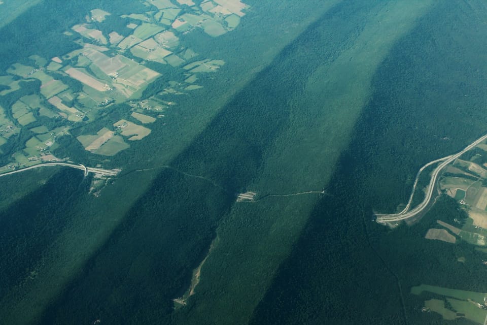
Northeastern Pennsylvania is ridge-and-valley country. The Appalachian ridges here run roughly northeast-to-southwest. Moosic Mountain, Spring Mountain, North Mountain, Elk Mountain, and the valleys between them are where most people live. The Wyoming Valley, the Lackawanna Valley, the North Branch Susquehanna corridor.
That geography is hostile to 915 MHz radio. Not because the band is weak, it isn't, but because line-of-sight matters and these ridges are walls. A node on the valley floor in Scranton and a node on the valley floor in Carbondale are maybe twelve miles apart. They will never hear each other unless something is in the way to relay, or unless one of them is on top of something.
The same ridge that makes your commute annoying on Route 6 in winter is blocking your mesh traffic year-round. Understanding that is step one.
Line of Sight Is Everything at 915 MHz
At 915 MHz, radio behaves close to optical line of sight with a small additional clearance zone called the Fresnel zone. A hill, a ridge line, a dense tree canopy, these absorb or scatter the signal. The math is simple: if you can't draw a straight line in 3D space between two antennas without hitting terrain, the link is degraded or gone.
This has two practical implications:
Elevation above obstructions matters more than absolute elevation. A node at 800 feet ASL on a bare ridge beats a node at 1,200 feet ASL buried in a stand of mature hemlock on a north-facing slope. Get the antenna above the stuff around it. For a roof mount, ten feet of mast clears most residential rooflines and chimneys. For a ridge deployment, the antenna needs to clear the tree canopy, which in NEPA hardwood forest is 60–80 feet. Even a 30-foot mast changes the math dramatically.
One good high node does more than three mediocre ones. A router node at 1,800 feet on the Elk Mountain ridge can see across the entire Wyoming Valley and into the Endless Mountains to the north. It connects nodes that would otherwise be in separate isolated clusters. Effort invested in one excellent placement outperforms scattered low-effort placements every time.
Read the Shadow Map Before You Climb
Before you commit to a site, before you talk to the landowner, before you drive out there with a ladder, look at the shadow map.
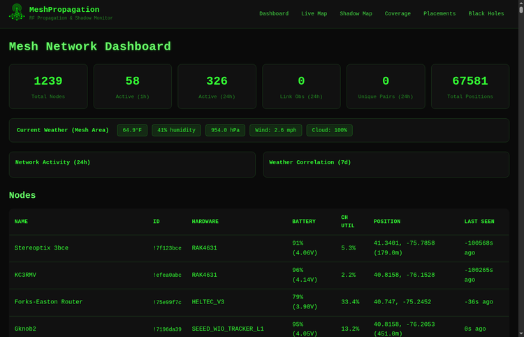
propagation.nepamesh.com is NEPAMesh's RF propagation monitoring tool. The Shadow Map view shows you exactly where the current node network has coverage and where it doesn't, based on actual terrain modeling from SRTM elevation data. Red zones are dead zones, areas where the network can't reach. Green is coverage.
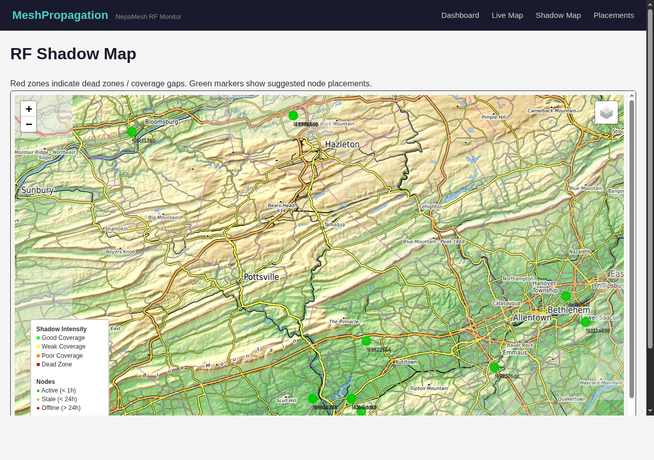
What you'll notice immediately: the red zones follow the valleys and the north faces of ridges. The green concentrates at higher points and along the ridge crests where current nodes are already deployed. That map is telling you where the next node needs to go.
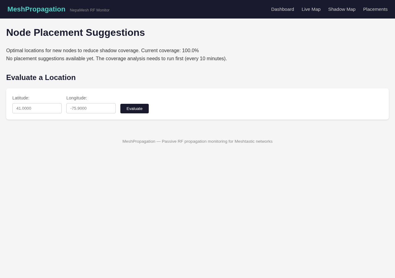
The Placements page takes it a step further. Enter a latitude and longitude, a potential deployment site you're considering, and the tool evaluates how much shadow coverage that location would eliminate. It runs the terrain analysis and tells you whether that spot would meaningfully close a gap. Use this before you drive anywhere.
The tool refreshes every ten minutes as nodes come online and offline. Watch it over a few days and you'll see which parts of the network are consistently thin, which areas depend on a single node staying up, and where a single good placement would do the most work.
NEPA-Specific Rules of Thumb
Ridge crests: yes. Moosic Mountain, Elk Mountain, Spring Mountain, North Mountain, anything on or near the crest has potential for long-distance links. Ski areas along these ridges are often interesting candidates: they have existing infrastructure, they're already permitted for structures, and they sit on high ground by design.
The Pocono plateau: surprisingly good. The plateau sits at 1,500–2,000 feet and is relatively flat on top. Nodes there don't need dramatic elevation above the terrain, they're already up. The challenge is the steep eastern escarpment; a node on the plateau looks west easily but the drop toward Monroe County communities below creates a coverage shadow on that edge.
Valley floors: avoid for range nodes. The Wyoming Valley floor, downtown Scranton, Wilkes-Barre, Kingston, Pittston, is surrounded by 500–800 feet of ridge on multiple sides. A node there connects to its immediate neighborhood and not much else. A USB-powered router on a windowsill there is fine. A solar node you're hoping will do long-haul relay work: wrong place. The exception is a building tall enough to clear the surrounding urban clutter and see the ridges.
The North Branch corridor: underserved. The Susquehanna runs through a valley connecting Wilkes-Barre to points north. Tunkhannock, Towanda. The river corridor itself is a shadow zone, but nodes on the valley walls rather than the floor can relay traffic up and down the corridor. This is one of the areas where a few good placements would do significant work for the network.
Finding a Site: Where to Look
Once the terrain tells you it wants a node on a ridge, the question is whether you can actually put one there.
Your own property first. A rooftop node on the highest house on your road is often better placed than anything in the valley. Check the shadow map for your own address. If you're on high ground, start there, no permission needed, easy access for maintenance.
Neighbors and community members. The homeowner on the highest lot on your road, the hobby farmer with a barn on the crest of a hill, the hunting camp up on the ridge. A Meshtastic node is small, solar-powered, and runs without attention. Most people are happy to host one when you explain what it does and show them it works. Bring a working node, show them the app, it's an easy conversation.
Get written permission. Even informal, a text exchange, an email, have something in writing that says you're allowed to install a device and that you'll remove it if asked. For a $70 solar node, a written agreement protects both parties and makes things straightforward if the property sells or the situation changes. Don't skip this step.
Local ham radio clubs. This is the underused option. NEPA has active amateur radio clubs serving the area, including Murgas Amateur Radio Club, the Amateur Radio Association, and the Scranton Pocono Amateur Radio Klub. Ham operators already understand RF propagation, already have relationships with hilltop sites, and in many cases already have towers on ridge lines supporting repeaters. A Meshtastic node on an existing ham tower is a natural fit.
If you'd like to reach out to a club in your area, we've put together a ready-to-send email template that explains the project, what you're asking for, and what's required on their end.
A ready-to-edit email explaining the NEPAMesh project, what site access involves, and why it matters, written for an audience that knows RF.
Download PDF
Fill in your name and contact info, then send to your local club. If you'd like to send from a nepamesh.com email address, stop by the NEPAMesh Discord, we can set one up for you.
Fire companies and municipal infrastructure. Volunteer fire companies often have stations at elevated locations, they're sited that way deliberately. Some have antenna towers or rooftops that would work well for a small solar node. Municipal water towers sit at the highest available points almost by definition. Borough and township buildings are worth a conversation. These take more coordination than talking to an individual neighbor, but the sites are excellent and the use case, community communication resilience, is one local officials often respond to positively.
Ski areas and communications sites. Ski resorts on the NEPA ridges have structures at elevation that have already solved the access, power, and maintenance problems. A cold call probably won't work; a connection through the local ham community or a direct conversation with operations or facilities staff is more likely to go somewhere. Frame it as a community emergency communication asset, because that's what it is.
Antenna Height Isn't Just About the Mast
When evaluating a site, think about what the antenna needs to clear, not just how tall the mast is.
At most residential sites, the main obstructions are the roofline and chimney (2–5 feet above the peak), neighboring structures within a few hundred feet, mature trees, and terrain that rises behind the site. A mast that gets the antenna 10 feet above the peak of the roof clears most of the near-field clutter. Beyond that, you're paying for mast height without proportional gain, the terrain limit matters more than the last few feet of mast.
One thing that catches people: don't mount the node directly under a metal roof overhang or gutters. Metal reflects and scatters 915 MHz. The antenna needs to be above the roofline, not sheltered by it.
For a ridge deployment with tree canopy, the calculation changes. If the trees around the site are 60 feet tall and you mount the antenna at 20 feet on a mast, you're still inside the canopy. You need to get above it, which means a taller mast or a location where the trees are shorter (along a road cut, at a cleared hilltop, in a maintained field). Deciduous trees in NEPA lose their leaves from November through April, which noticeably improves winter range from the same site. If a site looks marginal in summer, check it again in January.
The Confirmation Loop
After install, watch the shadow map.
The tool updates as the new node starts relaying traffic. If the placement is good, you'll see the red zone it was targeting start to shrink over the first few days. Other nodes that were previously unreachable may start appearing in the network list.
If the shadow map doesn't change much, there are two likely explanations: the site wasn't as clear as the terrain suggested, or the network gap in that area doesn't have enough nodes on either side generating traffic through it yet. Give it a full week before concluding the placement didn't work.
The Black Holes view on propagation.nepamesh.com shows areas where nodes are known to exist but have poor connectivity, weak signal to neighbors, lots of dropped packets. If your node shows up there after a few days, the site has a problem. Common culprits: U.FL pigtail not fully seated, antenna cable routed near a metal surface inside the enclosure, or obstruction that wasn't visible from the ground.
Before You Put It Up
Quick checklist before committing to a site:
- Check the address on the shadow map, is it in a gap that needs filling?
- Use the Placements evaluator, does the tool confirm the location would help?
- Do you have line of sight to at least one existing node? (Check the Live Map at propagation.nepamesh.com)
- Do you have written permission from whoever controls the property?
- Can you get back to it for annual maintenance without too much difficulty?
- Is the enclosure mount oriented with cable entries facing down?
- Is the solar panel facing south and tilted to your latitude?
If yes to all of those, put it up. Share the location in the NEPAMesh Discord, we'll add it to the map and watch the shadow map together to confirm the coverage gain.
The mesh gets better one good placement at a time. Not one more node in the valley, one node on the ridge. The shadow map will show you where. The terrain already told you which ridges. Now it's just a matter of asking.
Meshtastic is a registered trademark of Meshtastic LLC. No warranty is provided, use at your own risk. This post is not endorsed by or affiliated with Meshtastic LLC.